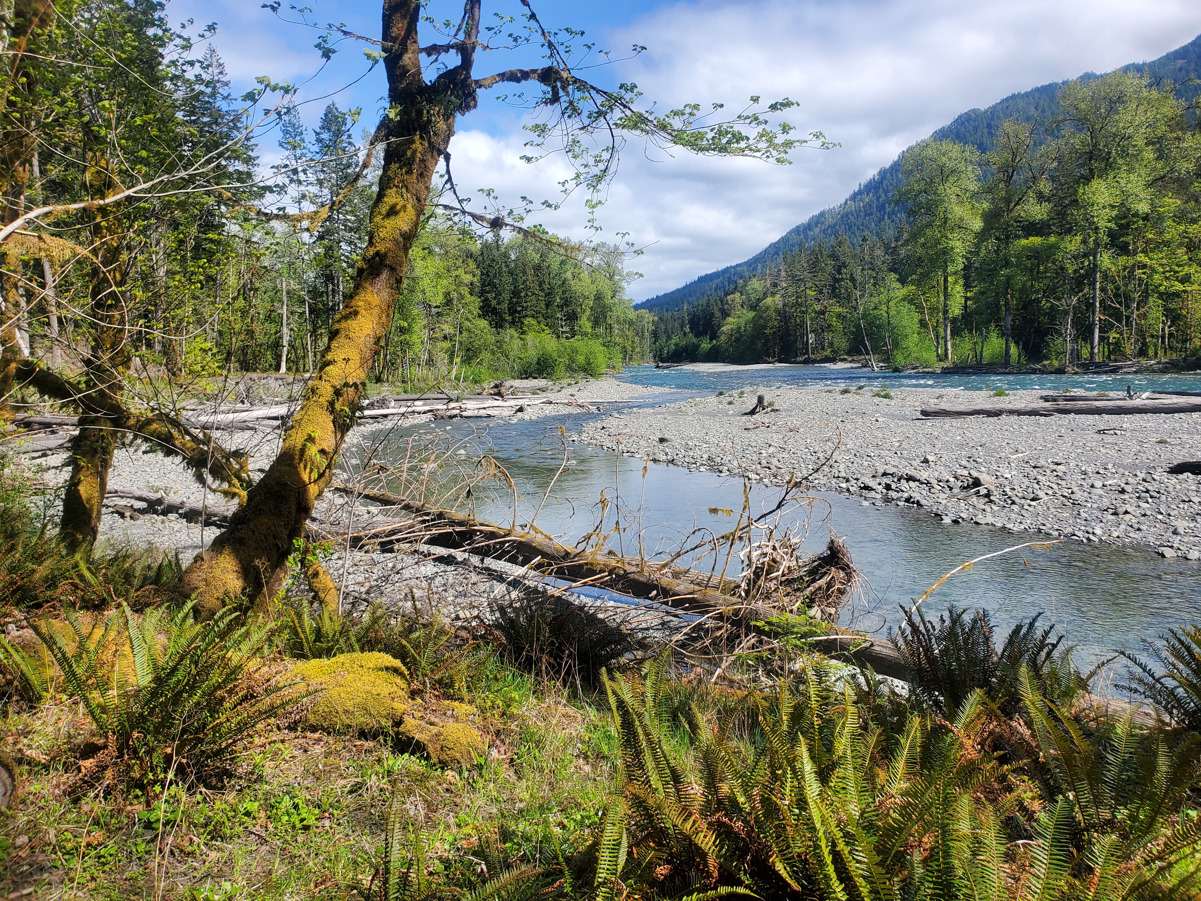
When the two dams on the Elwha River were removed in 2011 and 2012 – the largest dam removal project to date in the United States – the areas behind the dams which had been under water became exposed. Millions of tons of silt washed downstream to the ocean, the Strait of Juan de Fuca. A couple years after that, the river channel shifted and shifted again, twice cutting the access road leading south from Route 101 a few miles to campgrounds, maintenance sheds, and dirt roads to trailheads. The picture above is taken at the road end looking across to where the road once ran.
The Elwha River runs through some amazing canyons, and a couple narrow defiles within which the dams were built more than a century ago to provide power to local lumber mills and Port Angeles. Now, with the dams gone, you can go to a walkway and overlook where the dams were. The narrow gorges thunder with current.
The Olympic mountains are drained by a series of rivers that flow in all directions from a high central point deep in the park – north, east, south, west. None of the rivers is more than 45-50 miles long. They drain the snow-covered marine-influenced slopes of the Olympics, which lie within sight of the Pacific Ocean. The rivers are active, flow year round, even during the summer drought, and often flood with rain and snow melt. The channels are many, deep, and swing from side to side through the narrow valley bottoms, shifting course all the time. There are sections on all the rivers where the river bottom land is generally flat and anywhere from two hundred yards to a half mile wide, at least on the lower sections below the alpine meadows and steep upper canyons. This river bottom, especially on the western slopes of the mountains in the rain shadow, is filled with huge spruce and cedar trees, enormous, many over 500 years old.
The first years I was near the Olympics I often hiked along the Gray Wolf River, which drains the northwest area and a narrow valley. From year to year there were huge changes. The current would swing against one steep side bank, undercut it, sweep away the trail, topple trees, then swing back toward the other side, carrying the trees downstream to pile up and be filled with rocks and debris. The amount of trail maintenance needed throughout the park is enormous. The landscape is dynamic and always changing. There was a bridge crossing the Graywolf about four miles in from the trailhead which washed away about 20 years ago. It has never been replaced. Now, to get to the upper Graywolf area, you need to park at Slab Camp or Deer Park and first go downhill.
I noticed that when the Graywolf changed course it would reveal white ancient trees beneath rocks, logjams covered with debris from floods decades, even centuries before, and it struck me that the river probably sweeps back and forth throughout the valley bottom over the years such that every square foot of the valley bottom is at one point or another swept away, then re-emerges when the current goes elsewhere. In the wider valleys, the Bogachiel for example, you walk through three or four deep sub-channels before reaching the river proper, channels made during earlier channel sweeps and now left high and dry. The channel will sweep back again, back and forth, over the years and centuries, changing all, lowering the valley bed, bit by bit. If you hike the North Branch of the Quinault you go through river bottoms, as on the Queets, where you know you are crossing an earlier channel but now there are huge trees in that channel.
And this led me to a speculation – if it is true, as it seems to me, that these rivers fully sweep their valley bottoms over time, the maximum age of the trees found in those valley bottoms will be roughly the period of a full sweeping. This leads me to guess that it takes between 500 and 800 years for one of these rivers to fully sweep its course, and suggests that perhaps the reason we don’t find trees older than 800 years is not because such trees cannot live that long, but because the water gets them first. I’ll bet, too, that the first people here camped on the river valleys, maybe for thousands of years, but their villages, and evidence, was washed away, too.
Well, the river took the road into the Elwha and Elwha upper dam and the ranger complex and the Whiskey Bend parking lot road after the dams were removed, cutting the road twice against the eastern bank and isolating about a half mile of old road and a former campground. Now that road ends, with signs, and a side trail has been built to walk beyond the changed course, which undercuts the eastern bank. There have been arguments and talks about whether and how to repair the road for years. It will be horribly expensive and difficult, and as of yet nothing has been done. The road ends, you must park, and then you walk the old road three quarters of a mile to where the river has cut away. Beyond, back on the road above the second cutting, lie miles of unused road, pavement beginning to come apart, nice buildings that are no longer used, and a sense of some kind of abandonment. It is both beautiful and a little eerie. It used to be you could drive to the Whiskey Bend parking lot before hiking into the park, it was a major trailhead. Now you need to walk over 8 miles to get there. Another trailhead, to Olympic Hot Springs and Appleton Pass, and a crossover to the Sol Duc area, is similarly now miles distant.
On the eastern side of the Park, the Dosewallips road once led through a narrow canyon to a large campground and ranger station. This road, maybe 15 years ago, fell into disuse, the roadbed shifted in rains, and it has been closed for years, as has that ranger station – another formerly popular and easy access to the park interior now gone. To the south, the road to Enchanted Valley, and Graves Creek, has been undercut by the river a few times, and closed, but repaired.
It is a constant battle, always changing, dynamic, powerful. Those rivers are not long, not large, but they are intent, you know? Here we have a National Park set aside to be natural, and so it naturally changes to overcome and alter our efforts to build and maintain roads and trails, and yet these Parks are for use by the public, so they need access. A conflict, inherent in the situation, is always present.
Those rivers don’t know that, though. They’re just sweeping that river bottom, back and forth.
