A little perspective…

From November 2022: I’m still out here on the north side of the Olympic Peninsula and the Strait of Juan de Fuca. That container ship that was burning sits about 20 miles from me, north, across the strait, near Victoria, fire now contained, perhaps even out. That monster storm that came through was a big one but no catastrophe, and it seems whatever struck all those waiting ships off California did not blow them all onto shore. There is snow in the higher elevations, creeping lower and lower as the air cools.. There has been a lot of rain. This has been, in fact, a fairly typical last week of October weather pattern for these parts.

We’ve been staying in a cabin not far from the Elwha River, maybe 10 miles west of Port Angeles, way up an old road near the end, among scattered houses, fields, trees, hard next to National Forest land and the national park. The other day the local herd of Roosevelt Elk, over 40 animals, wandered into the field behind this place and visited for an afternoon. They were magnificent.

This area, off Highway 101, just west of the river, was once called Elwha, one of the many forgotten local towns settled by pioneers before 1900. The little schoolhouse, built in 1908, still stands, now a community center. There is a long history of some local families here, written one Alice Alexander, grand daughter of a woman born on the homestead in the early 1890s who lived to 95, about her ancestors who came to this country when it was the remote end of civilization, to build homesteads, then houses, then a community. I am certain many of the homes out here are still owned by descendants of these families, great and great-great grandchildren of those pioneers.

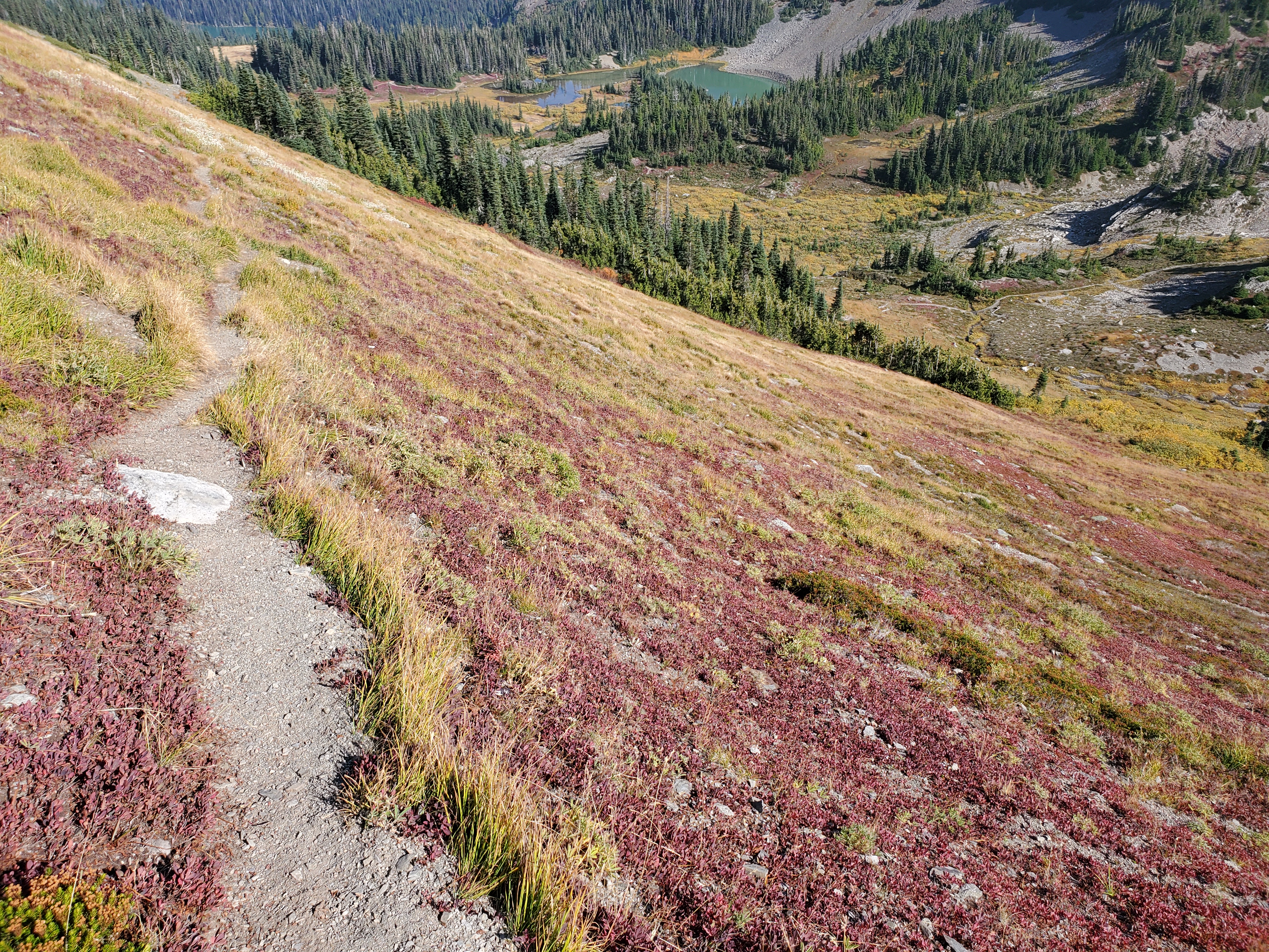
The Olympic Peninsula in Washington State was one of the last settled regions in all of the continental United States. While there is absolutely no doubt in my mind that the native people here knew every inch of the entire peninsula, tree and trail, including the rugged and difficult to reach interior, the river headwaters and mountains were not properly mapped and surveyed until the late 1890s. This peninsula contains many recognized tribes of First Peoples, all with treaty fishing and hunting rights, and their presence and culture here is clear. On several roads leading to trailheads in the national park you will still pass cabins of huge logs, without roofs, 12 to 16 feet square, original homes of the original homesteaders.

Some of the greatest stands of timber in all the world grow here, and logging was the original and basic industry. My father worked in the logging woods in 1935-36 and he came to love the work and this area, which may be why I moved this way myself in 1990. The land, years ago, was a federal forest, and early on some people argued for its preservation while others argued for its exploitation. The easiest to reach timber stands, the lowlands, were huge, just enormous, but demand for lumber was steady and strong.

There is this story of how Olympic National Park came to be. It might be true. It is said that in 1938 timber barons convinced the President, Franklin Roosevelt, to come visit the peninsula, and they took him on a tour to convince him to open the rest of the federal land to logging. Roosevelt, arriving and seeing the grandeur of the country, instead made it a national park, a park that has grown in the decades since with newer adjacent wilderness areas. But logging continues, some stands of trees now logged and regrown three or four times.

Back in the earliest years of the 20th century, when the first settlers were building that school for their kids, the best way to get from Port Angeles to Seattle was by taking the steam packet, or ferry. That was a lot faster than walking or taking a horse drawn wagon on the terrible roads, over 100 miles, or trying to drive those roads in the newly invented motorcar.

But we humans are industrious, creative, and energetic. Maybe the interior of the peninsula was still uncharted in 1895, but by 1920, a quarter century later, there were roads all around the peninsula, trails all through the soon-to-become park, and lumber mills everywhere.

Now, a century later, nearly every single one of those dozens of lumber mills is no more, closed, removed, taken away. The dozens of salmon plants that once lined Puget Sound’s shores are gone. Almost every single original settler cabin has rotted away, been covered by other homes, or parking lots. Here at the foot of the road this cabin is on, downhill by Indian Creek, there is second growth forest, big tall trees, and no sign whatever of the shingle mills and lumber mills once there. One of the people who lived in this little community in 1905 or thereabouts, according to the family history here, was hunting up the Elwha River and a tributary and came upon some hot springs. (I suspect the truth is the First Peoples knew about these springs and told him.) He cut a trail, got some pack animals, and began ferrying people up to soak in those springs. Then he built, up there – this was at least 12 miles from this community, uphill all the way – a building to take customers, and later more buildings. There was an Olympic Hot Springs Resort and he made a business taking people up there to soak in the pools.

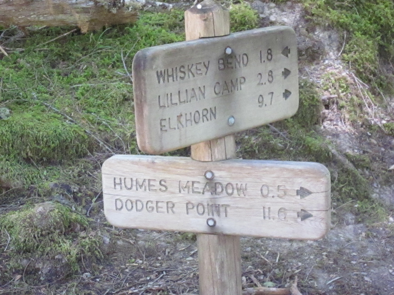
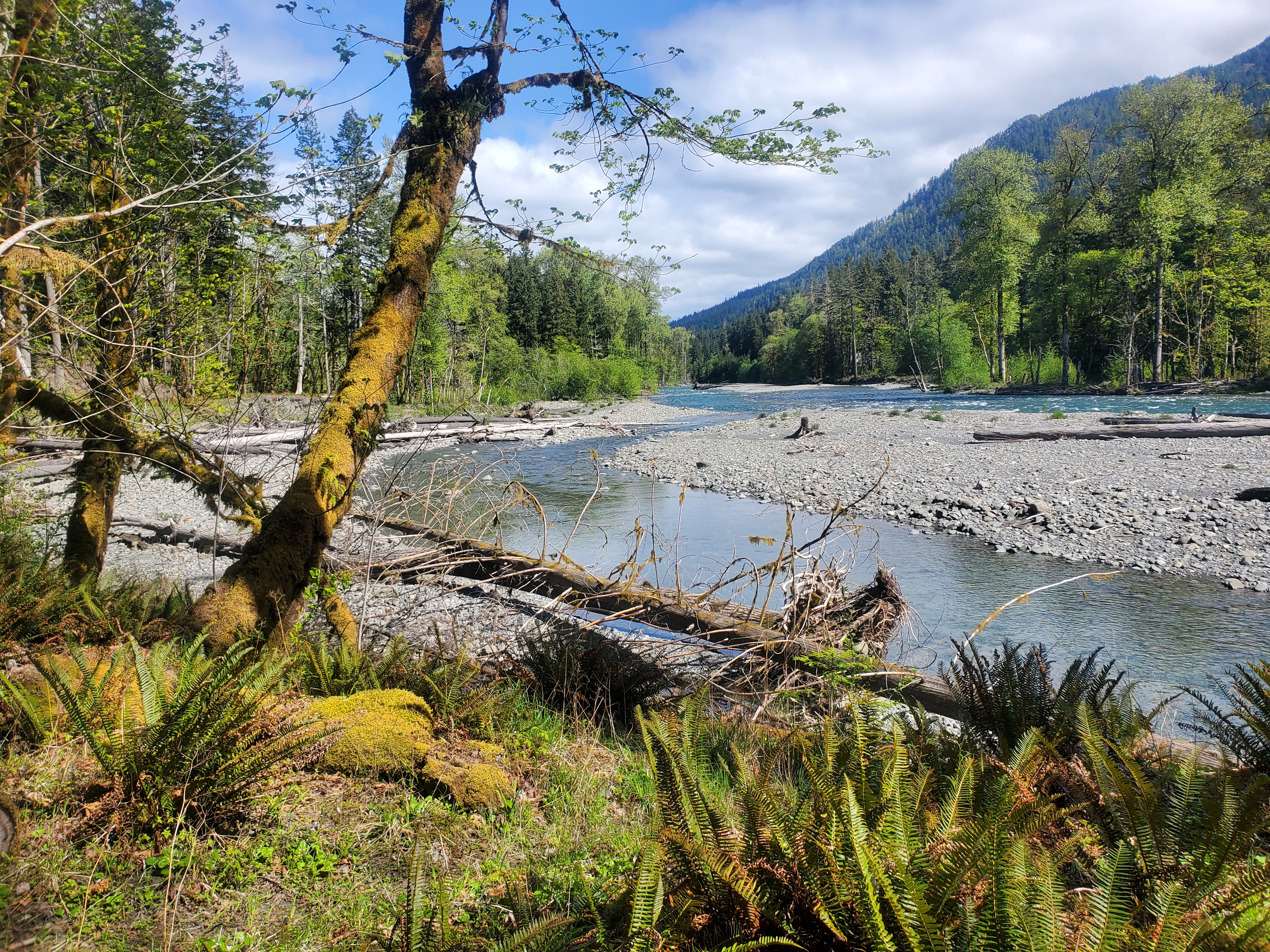
In the 1920s a second dam was built on the Elwha (the first was built downstream in about 1913) to power the local city and mills, and to build that dam a road was built and this road then carried on to those hot springs, a dirt road which still exists. By the late 1930s there were three buildings up there, cookhouses, sleeping rooms, maintenance sheds, the works. But then the business began to fade, and by 1940 the place closed, by then located within the borders of the national park, so some time after 1940 the park people removed all the buildings and everything else. I have been through that area a few times, and while there is still a dirt road leading to the pools, there is no evidence whatever of any resort, none. The pools are still hot, and used, but since the Elwha River washed out the access road only three miles from Route 101 there is no way to drive to the trailhead to the springs any longer, or, for that matter, other trailheads once accessed by roads.

The reason for the road washout? Both those dams, which by the way stopped salmon migration within six miles of the 50-mile river’s mouth, a salmon run that featured 100 pound king salmon, were closed in the 1970s and 1980s and then removed, with the last dam gone in 2014 or so. This was the biggest dam removal project in United States history. The removed dams swept millions of yards of sediment downstream and the river bed shifted and shifted again and cut off the access road, and a repair is barely in sight.

And that pack trail used years ago to get to the hot springs? It is now called the West Elwha Trail and still exists, I and my wife have hiked it many times, but now it only leads to the road that was later built, maybe five miles in.

All of which to say, in just the 130 years since this land was first opened, or settled by non-native people, most of the ancient forest has been cut down but then regrown (except for the heart of the peninsula where the million acre park lies, which is still pristine), two dams have been built and then removed (and the big salmon seem to be coming back), all evidence of dozens of lumber mills and resorts has been removed, there still exists a local economy based on some logging and services and recreation to the national park and surrounding areas, but things are tough, out this way, just as they seem tough in all out of the way places.

But – and this may be important – all those years ago when all that work and building was done, people fed themselves with local crops, used local materials for construction, made do with whatever they had, and, living in country they loved, appreciated what they were given and refused to complain about what they were missing. Maybe they did this because this was all they knew.

I am pretty sure, faced with our modern circumstance of hysteria imagining a delay or, God forbid, no shipment of items for the Christmas season, they would look at each other and smile before heading out back to start making toys…

How old might the high trails in the Olympics be?

Up high – that is, above the thick forests – the terrain in the Olympics is entirely different. Up high lie meadows filled with grasses and clumps of trees, or acres of broken shale and flowers, rocks and cliffs, broad basins that lie open below the sky. These areas, usually above 4000 to 5000 feet, lie beneath snow for months of the year. The first snows fall in late October to mid-November and linger until late May in the lower areas and as late as August higher. There are places where the snows fail to melt for years at a time. This means that the open meadows and streams and tarns and lakes lie open to the sun and warmth for at most five months a year, and usually much less than that. The alpine growing season is probably 100 to 140 days a year, and in that time everything has to take place – the seeding, growing, flowering, turning.
There is a little tarn on the way in to Grand Valley, just before or after the seasonal ranger tent, about the size of a bedroom, less than a foot deep, within which frogs breed, casts eggs, the eggs hatch, tadpoles form, and then the tadpoles become frogs, all within that 120 day window, all of it, such that the frogs are old enough to find a place to bury themselves and survive the long long winter. That little tarn always had frogs in it through out the 1990s and 2000s, then in about 2016 when I got back up there after a few years away at sea that tarn was barren, dry, bare earth, without frogs, but a couple of years later there water was back and so were the frogs.
It is hard to guess the biological energy that must flow up in those alpine areas, all that growing and breeding and nurturing and then dying, happening so fast. Surely the flux must equal that of a rain forest, at least during those days of high sun, warmth, and growth. But the alpine areas are fragile, too, the topsoil thin, the roots holding plants to the soil somewhat fragile. The plants and roots are strong enough to withstand the weight of the snows, and the passage of avalanches in the spring, although trees are torn free and tumbled, and in many of the meadows the marmot populations dig burrows and alter the earth and cast aside soil, such that anyone walking across such a meadow must be careful lest they step into a deep hole. The elk go high in the summer, very high, living in those basins and meadows, and they have done so as long as elk have lived in this land, returning again and again to known areas and haunts, and, being heavy animals, tracking game trails across meadows and basins, some trails wide and over the aeons pounded deep into the earth, as much as six inches or a foot.
There is evidence the first peoples who lived on the Olympic Peninsula wandered the high country as long as 7,000 years ago, and possibly much much longer. The oldest confirmed site with evidence of hunting in the Americas, a spear point embedded in a mastodon bone, was found in a Sequim prairie below the foothills of the northern Olympics, dated to 13,800 years ago. There are dozens of areas in the Park that are ancient, remote camps and sheltering places, used by human beings for hunting, wandering, gathering herbs, and it is more than likely they followed those game trails up high to get from one basin to another, further marking those trails on the earth. And, it is surely the case then that the first white explorers in the Park, in the late 19th century (though trappers may have been in there as early as there 1840s) followed those trails as well, and then, later, in the 1920s, when a trail system was conceived and developed, the higher trails surely connected together the already existing trails across basins and meadows. Even today, when you go high, you can be sure that many of the paths you follow are ancient, thousands of years old, perhaps even tens off thousands of years old.
So, while the lower elevations of the Park are dynamic, always changing, in great flux as trees fall and rivers erode banks, and landslides carry sections to valley bottoms, in the higher alpine zones, except for avalanches, there are surely areas that have not changed at all for a long long time. First of all, those areas, being covered with snow two thirds of the year, age at one third the rate of areas lower down. More importantly, though, the trails first made by game and then followed by humans were initially formed as the animals followed the path of least resistance to get from one place to another, and because the landscape does not change that much century to century, up high, neither will this trails. This means that when you are hiking up there, following a well trod path, you are probably walking the very same path followed by people who walked there before agriculture rose, even while the great ice, which filled Puget Sound but did not cover the Olympics, which stood as a bulwark holding the ice sheet from the Pacific Ocean south of the Strait of Juan de Fuca, lay in a great miles thick sheet to the east.

Trails in the Olympics

There are, roughly, 900 miles of trails in the million-acre Olympic Peninsula National Park and adjacent wilderness areas. Anyone who hikes there immediately sees the work it takes to keep the trails clear, at least in the forested valleys and slopes. The whole system – rivers, slopes, forests – is incredibly dynamic. There are floods, landslides, fires, avalanches, windstorms, and even occasional earthquakes. The huge trees – Douglas firs, cedars, spruces – have root systems that tend to spread out rather than dig deep into the earth, wide circular spreads of roots just a few feet beneath the soil (which is mostly dirt mixed in with rocks and the limbs of former trees) and after it rains for weeks during the rainy season the soil becomes sodden and slurry-like, and then when the wind blows the trees topple, pulling up a big root ball of roots, dirt and rocks, leaving a hole, and often occurring in groups of blown down trees, for when one goes, so do the others behind it.

All of which to say that every year, on nearly every trail, some trees fall across the trail, water gullies erode the trail, and sections of the trail disappear. This is even worse along the rivers, which themselves are dynamic, sweeping back and forth against steep banks, and then an entire quarter mile of trail can vanish into the river, requiring an entirely new trail to be built further away.

Trail maintenance is damn hard work. It requires engineering, the movement of heavy rocks, the cutting and moving of huge trees, constructing rock dams against which earth is then placed for a tread path, the use of plastic pipes to channel water beneath a trail section, placement of stone channels to guide the runoff, and a host of other efforts. I’ve gone out with work parties a few times myself, and it’s damn hard work, harder than backpacking, and most hikers aren’t even aware of the hours of painstaking work someone has done to leave a trail that is walkable. If you hike in these forests, you are likely to see a Park or more likely a volunteer trail maintenance crew, some times way deep into the back country, with hard hats, chain saws, axes, shovels, mallets, often horses to carry their gear, often camping out for several days, working on a section. This is in addition to the annual cruises somebody does every spring, everywhere, cutting free those trunks that have fallen across the trail. Lots of trees fall. The Park Service has a trail report system, and in the spring the first hikers who go in to the trails, especially on the western side of the park, where it is wetter, report 60, 80, 120 trees down across a trail which might be 10 or 20 miles in length.

Once you first notice the amount of work taken to keep a trail clear, you always see it – the butt ends of sawn through logs that fell across the trail, the sections tossed off into the understory beside the trail, the amount of rock and soil work to keep the trail path level and firm. Without all this work, there are trails in this system that would literally vanish within five to ten years, covered with fallen trees, washed away, grown over. Moving through the lowlands, beside the rivers, or along the slopes, at times can be relatively easy, because the understory can be rather open, especially higher, or down on the river bottoms where the trees are huge and don’t fall that often. But there are other areas, many, that are virtually impassable, either because they are so steep and rocky, or because they are so thick with growth.

The first time I ever walked into the Duckabush, back in 1991, I followed the trail over Little Hump to a lowland, which paralleled the river before climbing steeply to Big Hump, and in that area there was a huge blow down, probably from that ferocious windstorm from December 1990 that blew out the floating bridges, and it took me half an hour to find the trail on the other side. I bet there were 100 trees down. Now, almost 30 years later, I can still see evidence of that blow down, but not easily. A couple years ago I dragged my brother in law with me to the South Fork of the Hoh, having this bright idea we’d go on past the trail end and work up the river to the Valhallahs and the high country there. We got to the trail end fine, it was a lovely hike, but bush whacking beyond was impossible. Impossible, at least for the two of us, admittedly near geezers, because the growth was impassably thick. We were there in May, and the river was high with snowmelt, and we thought, maybe in August, when the water drops, people can work along the river bars far upstream, avoiding the brash and thickets on the shore.

It’s easy to see why the first pioneers who came out to this country thought that nobody ever went into the interior of the mountains. Trying to move through the blown down trees and thick brush with heavy gear and horses would be almost impossible. It took the Press Expedition nearly six months to traverse the Park north to south in 1893, a distance of less than 60 miles. About a decade ago I drove by Camp Parsons, the famous Boy Scout Camp on the Hood Canal which has been sending troops of boys into the Olympics since as early as the 1920s. Our across the street neighbor in Ballard, who died at 94 about five years ago, Frank, went to Camp Parsons in the 1930s, and he hiked all through the park on the trails then, many the same as we hike today, and he later climbed Mt. Rainier 40 times.  I wanted to see this camp, and there it was, and someone who worked there, as old as me, told me with authority that the Indians never went into the interior of the Park.  He was, and is, dead wrong, of course, native people have been going all through that country for thousands of years, but I think it might have been as hard for them to work through the lowlands as it was for the first pioneers a century and more ago, except for the simple fact that once the light bulb goes on and you start following elk tails, everything becomes easy. Elk know better than anyone how to find a way through the thickets, how to avoid the gullies that draw you in then drop you into steep dangerous falls, how to turn away from the cliff ahead.

I have another theory as to how the First Peoples traveled in the Park, and how old some of the trails really are, but that is another discussion.

Sweeping Rivers….

When the two dams on the Elwha River were removed in 2011 and 2012 – the largest dam removal project to date in the United States – the areas behind the dams which had been under water became exposed. Millions of tons of silt washed downstream to the ocean, the Strait of Juan de Fuca. A couple years after that, the river channel shifted and shifted again, twice cutting the access road leading south from Route 101 a few miles to campgrounds, maintenance sheds, and dirt roads to trailheads. The picture above is taken at the road end looking across to where the road once ran.

The Elwha River runs through some amazing canyons, and a couple narrow defiles within which the dams were built more than a century ago to provide power to local lumber mills and Port Angeles. Now, with the dams gone, you can go to a walkway and overlook where the dams were. The narrow gorges thunder with current.

The Olympic mountains are drained by a series of rivers that flow in all directions from a high central point deep in the park – north, east, south, west. None of the rivers is more than 45-50 miles long.  They drain the snow-covered marine-influenced slopes of the Olympics, which lie within sight of the Pacific Ocean. The rivers are active, flow year round, even during the summer drought, and often flood with rain and snow melt. The channels are many, deep, and swing from side to side through the narrow valley bottoms, shifting course all the time. There are sections on all the rivers where the river bottom land is generally flat and anywhere from two hundred yards to a half mile wide, at least on the lower sections below the alpine meadows and steep upper canyons.  This river bottom, especially on the western slopes of the mountains in the rain shadow, is filled with huge spruce and cedar trees, enormous, many over 500 years old.

The first years I was near the Olympics I often hiked along the Gray Wolf River, which drains the northwest area and a narrow valley. From year to year there were huge changes. The current would swing against one steep side bank, undercut it, sweep away the trail, topple trees, then swing back toward the other side, carrying the trees downstream to pile up and be filled with rocks and debris. The amount of trail maintenance needed throughout the park is enormous. The landscape is dynamic and always changing. There was a bridge crossing the Graywolf about four miles in from the trailhead which washed away about 20 years ago. It has never been replaced. Now, to get to the upper Graywolf area, you need to park at Slab Camp or Deer Park and first go downhill.

I noticed that when the Graywolf changed course it would reveal white ancient trees beneath rocks, logjams covered with debris from floods decades, even centuries before, and it struck me that the river probably sweeps back and forth throughout the valley bottom over the years such that every square foot of the valley bottom is at one point or another swept away, then re-emerges when the current goes elsewhere. In the wider valleys, the Bogachiel for example, you walk through three or four deep sub-channels before reaching the river proper, channels made during earlier channel sweeps and now left high and dry. The channel will sweep back again, back and forth, over the years and centuries, changing all, lowering the valley bed, bit by bit. If you hike the North Branch of the Quinault you go through river bottoms, as on the Queets, where you know you are crossing an earlier channel but now there are huge trees in that channel.

And this led me to a speculation – if it is true, as it seems to me, that these rivers fully sweep their valley bottoms over time, the maximum age of the trees found in those valley bottoms will be roughly the period of a full sweeping. This leads me to guess that it takes between 500 and 800 years for one of these rivers to fully sweep its course, and suggests that perhaps the reason we don’t find trees older than 800 years is not because such trees cannot live that long, but because the water gets them first. I’ll bet, too, that the first people here camped on the river valleys, maybe for thousands of years, but their villages, and evidence, was washed away, too.

Well, the river took the road into the Elwha and Elwha upper dam and the ranger complex and the Whiskey Bend parking lot road after the dams were removed, cutting the road twice against the eastern bank and isolating about a half mile of old road and a former campground. Now that road ends, with signs, and a side trail has been built to walk beyond the changed course, which undercuts the eastern bank. There have been arguments and talks about whether and how to repair the road for years. It will be horribly expensive and difficult, and as of yet nothing has been done. The road ends, you must park, and then you walk the old road three quarters of a mile to where the river has cut away. Beyond, back on the road above the second cutting, lie miles of unused road, pavement beginning to come apart, nice buildings that are no longer used, and a sense of some kind of abandonment. It is both beautiful and a little eerie. It used to be you could drive to the Whiskey Bend parking lot before hiking into the park, it was a major trailhead. Now you need to walk over 8 miles to get there. Another trailhead, to Olympic Hot Springs and Appleton Pass, and a crossover to the Sol Duc area, is similarly now miles distant.

On the eastern side of the Park, the Dosewallips road once led through a narrow canyon to a large campground and ranger station. This road, maybe 15 years ago, fell into disuse, the roadbed shifted in rains, and it has been closed for years, as has that ranger station – another formerly popular and easy access to the park interior now gone. To the south, the road to Enchanted Valley, and Graves Creek, has been undercut by the river a few times, and closed, but repaired.

It is a constant battle, always changing, dynamic, powerful. Those rivers are not long, not large, but they are intent, you know? Here we have a National Park set aside to be natural, and so it naturally changes to overcome and alter our efforts to build and maintain roads and trails, and yet these Parks are for use by the public, so they need access. A conflict, inherent in the situation, is always present.

Those rivers don’t know that, though. They’re just sweeping that river bottom, back and forth.

Olympics snow cover

It seems, during the 31 years I have lived in or near the Olympic Peninsula, that in the fall there are always articles worrying about the year’s predicted snowfall, claims that the snow pack, which supports water supplies for lowland urban residents, will be lower this year because of increasing warmth, climate change, global warming. These fears are real, and, twice, were borne out – there have been two years when the snow pack was very very thin at the end of March, when seasonal melting generally begins. One of those years, 1991, I chose to hike the Skyline Tail in the southern Olympics, and had the snow pack been normal I’d not have made it, become lost up high. But that year there was virtually no snow.

The pattern seems to be this – there is a final warm Indian summer week or two in early to mid October and then the rains begin, which become snow up high. Several times there is enough snow to open ski areas by Thanksgiving week in the Cascades, Mt. Baker, Crystal Mountain, Stevens Pass, and, on the Olympics, there is deep snow as well.  However, then it seems, usually in the January-February time frame, that snowfall nearly ceases, and by the end of February there are, again, stories and articles predicting drought, lack of snow, lack of water, climate doom.

Then March comes. And, nearly every single March, a ton of snow falls, tons and tons,  often well into April up high, feet on feet of snow, replenishing the snow pack such that by the end of the snow season there is usually sufficient snow cover to make it through the summer. Cliff Maas wrote about this a couple of weeks ago, pointing out that the average snow pack depth and supply had not changed much over thirty years, and, from this occasional hiker’s perspective, that is correct.

Some times there is enough snow to delay opening the road out to Obstruction Point in the Olympics, which is usually plowed free by mid June, and usually before July 4th weekend. A few times the road has not been cleared until late July, and once, maybe 15 years ago, not until the first week of August. It seems that this year will be one of these “late” years, as the current snow pack is 135 percent of “normal” and with a coolish spring predicted likely to last well into the summer.

So, up high, above say 3500 feet in the Olympics, the ground and plant life is covered with snow from mid to late October all the way until June or July, and, higher still, even into August. This means that there are 90 to 120 days only when the ground is bare and exposed to sunlight, and during this incredibly short time the entire life and reproductive cycle for plants and many animals must occur – budding, flowering, seeding. There are these little tarns up high which hold little frogs, and somehow these frogs emerge from beneath the chill and snow and mate, bear eggs, the eggs hatch, tadpoles swim, and become frogs – all in three months before the next snows fall.  If you’re up there during that time – and this is the time most people get up there – it is impossible not to notice the productivity of the plant life, the flowers, the blooms, the insects and birds and marmots and mice and voles, all filled with life, energy, making the most of the short, SHORT season. I have to believe that on a per acre basis the productivity up there in the sunlight and warm winds is as high as any rain forest.

Then, after that Indian summer week of hot sun, still air, heat, and the meadows bright red with the coming cold time, it rains and, up high, snows, the ground is covered and the eight to nine month sleep begins again.

I wonder, too, does the eight to nine month snow cover essentially freeze time up high such that anything deposited up there effectively ages at one third to one quarter speed? A few years ago someone found a woven basket melted beneath snow up toward the end of Obstruction Point Road. It was dated and found to be 2700 years old.

What else might lie up there?

Becoming lost in the woods….

Have you ever been lost in the woods? These days most of us, when we become lost, are more likely than not wandering an airport or big public parking garage looking for our vehicle. Right?

I’ve never been really lost out there. There are stages of lost-ness, I think. There is the “lost the trail” lost, which means wandering off a trail without realizing and then trying to find one’s way back. This is how most people get truly lost, this way, I think. I met a guy in my writing class in 2013 who went into the Olympics and started up the Three Lakes Trail toward Skyline ridge in the southwest Olympics, off the Quinault, and somehow missed a turn and ended up lost for five days. He got out OK, chilled, but that’s a long time to be missing. So he went from “lost the trail” to being really lost, but of course knowing the general area he was in. Then there is the totally lost condition, not even knowing the general area, this coming when say a plane crashes in the wilderness somewhere and you survive.

But, three times, I wandered off trail and was for a time “lost.” I wasn’t lost for long the first time. I was hiking up to Dodger Point and, low down, the trail jogs sharp left and up to start up the ridge after crossing the Elwha (I think that’s where it was, it was 25 years ago) and I kept going ahead, on the open forest floor, until say thirty yards in I realized I wasn’t on the trail any more. That was startling. An interesting thing happens to you when you lose a trail, or to me, anyway. Everything shifts. That first time I backtracked and sure enough found the jog right away.

The second time I was lost could have been more serious. I was alone, up on the Skyline Trail, July Fourth weekend a year with little snow, absolutely alone, my second day in, way up high past Kimta Peak, the next pass, maybe Hee Haw Pass? Anyway its rocky and bare up there, cairns, but enough snow to cover the cairns, and the trail there wanders down this rocky defile a ways then also jogs left over a little deep creek, but the ground is open and well trod and so I missed that jog and wandered this way, then that, and always the trail petered out. I am way in, it has just started to rain, and it then rained for three days, never been up there before, and now cannot find where the trail goes. That time it took me a half hour to find the jog and the trail. I knew enough to know that when you lose the trail you backtrack, first, and second you don’t go wandering off without a real clear idea of how to get back, because it’s rough country up there and if you get off far enough, down say a steep side hill, then you can get turned around and then you are lost, like my classmate got lost.

The third time is embarrassing. I had a new pair of boots, and hoped they were broken in. I had walked in them and gone up and down gravel sidehills with them, but they were new and I knew they were not yet ready, but it was a nice day, sunny, dead clear, I had the day off, and the Brothers beckoned, so I drove to the trailhead to Lena Lake, was on the trail by 6am, and tried to climb the Brothers. This, like the two events above, was the first or second year I was out here, maybe 30 years ago. I was younger than now and felt strong and was really stupid because right away I knew the boots weren’t ready but, dammit, the day was FINE, so on I went. The climber’s path to some campsites in the Valley of Silent Men is pretty easy to follow, and then you get above trees and I climbed up and up and up, in the hot sun, feet starting to burn, now, but dammit I was close! I reached the final summit block, where it gets a little exposed, and by now I know my feet are gonna be a big problem. I turned around maybe 200 feet below the summit and worked my way down to the campsites off the rock, which took a damn long time, several hours,  and when I got down there I got all turned around. I stopped and thought, I should take my boots off, but knew if I did I’d never get them on again. But somehow I got turned around and could not find the path down to Lena Lake. This took me two hours, wandering and looking. I was in a lot of pain and feeling stupid and not too rational, probably seriously dehydrated, nobody else around all day, afraid to remove my boots. That time, for a half hour, I was afraid I was really lost, wandering the woods, maybe getting further and further from the trail, and that was scary and sobering. I stopped and sat and took some breaths and relaxed, drank water, and checked the sun, the slopes, and found the trail.

I got back to my car at 7pm, 6000 vertical feet up and 6000 vertical feet down later, and when I took off those boots the skin on my feet up to my ankles came off too.

This was the first of several embarrassing boot stories, but (hopefully) the last of my lost stories, all of which were many years ago. But, still, that shift, that change, when you realize you don’t know where you are –  that gets your attention.